


Rand McNally
Rand McNally Easy to Read: Washington State Map
Rand McNally Easy to Read: Washington State Map
Couldn't load pickup availability
Author: Rand McNally
Brand: Rand McNally
Color: Multicolor
Features:
- Regularly updated, full-color maps
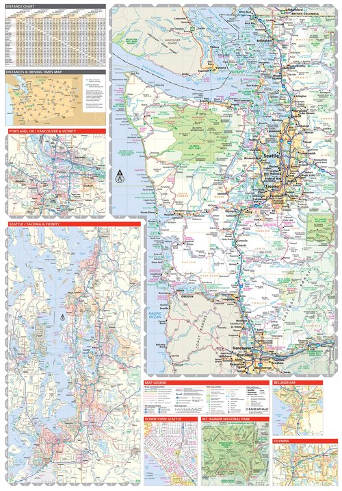
- 30% larger map with a bigger type size than the Rand McNally Folded Map
- Clearly labeled Interstate, U.S., state, and county highways
- Indications of parks, points of interest, airports, county boundaries, and more
- Mileage and driving times map
- Detailed index
- Copyright 2022
- Coverage Area Detailed maps of: Bellingham, Mount Rainier National Park, Olympia, Seattle/Tacoma & Vicinity, Downtown Seattle, Spokane, Vancouver, Yakima
Binding: Paperback
Format: Import
Release Date: 26-04-2024
model number: 0528028685
Part Number: 0528028685
Details: Rand McNally's Easy To Read State Folded Map is a must-have for anyone traveling in and around Washington, offering unbeatable accuracy and reliability at a great price. Our trusted cartography shows all Interstate, U.S., state, and county highways, along with clearly indicated parks, points of interest, airports, county boundaries, and streets. The easy-to-use legend and detailed index make for quick and easy location of destinations. You'll see why Rand McNally folded maps have been the trusted standard for years. - Regularly updated, full-color maps. - 30% larger map with a bigger type size than the Rand McNally Folded Map. - Clearly labeled Interstate, U.S., state, and county highways. - Indications of parks, points of interest, airports, county boundaries, and more. - Mileage and driving times map. - Detailed index. - Convenient folded size. Coverage Area Detailed maps of: Bellingham, Mount Rainier National Park, Olympia, Seattle/Tacoma & Vicinity, Downtown Seattle, Spokane, Vancouver, Yakima. Product Details: Dimensions (unfolded): 28" x 40".
EAN: 9780528028687
Package Dimensions: 9.4 x 4.1 x 0.3 inches
Languages: English
Share