


Rand McNally
Rand McNally Easy to Read: Virginia State Map
Rand McNally Easy to Read: Virginia State Map
Couldn't load pickup availability
Author: Rand McNally
Brand: Rand McNally
Color: Multicolor
Features:
- Regularly updated, full-color maps
- Clearly labeled Interstate, U.S., state, and county highways
- Indications of parks, points of interest, airports, county boundaries, schools, shopping malls, downtown & vicinity maps
- Easy-to-use legend
- Mileage and driving times map
- Detailed index
- Copyright 2021
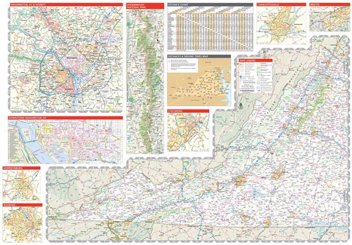
- Coverage Area Detailed maps include: Alexandria/Arlington, Bristol, Charlottesville, Hampton Roads: Norfolk/Newport News/Virginia Beach, Lynchburg, Richmond/Petersburg, Roanoke, Shenandoah National Park, Washington, D.C. & Vicinity, Williamsburg/Colonial National Historical Park
Binding: Map
Format: Folded Map
Release Date: 03-05-2024
model number: 0528028707
Part Number: 0528028707
Details: Rand McNally's folded map for Virginia is a must-have for anyone traveling in or through the state, offering unbeatable accuracy and reliability at a great price. Our trusted cartography shows all Interstate, U.S., state, and county highways and much more. - Points of interest. - State Park chart. - State mileage chart. - Driving times map. - Visitor center information. - Climate data. - State facts & symbols. - Easy-to-use legend. - Detailed indexed. Coverage Area Detailed maps include: Alexandria/Arlington, Bristol, Charlottesville, Hampton Roads: Norfolk/Newport News/Virginia Beach, Lynchburg, Richmond/Petersburg, Roanoke, Shenandoah National Park, Washington, D.C. & Vicinity, Williamsburg/Colonial National Historic Park. Product Details: Measures 9.0" x 4.125" and folds out to 25.5" x 36.75".
EAN: 9780528028700
Package Dimensions: 9.4 x 4.1 x 0.3 inches
Languages: English
Share